

Global warming is a critical issue that profoundly impacts ecosystems, climate patterns, and human life worldwide. Since the Industrial Revolution, increasing greenhouse gas emissions have led to a rise in the Earth’s average temperature, causing various environmental and social problems. Satellite images stand out as a powerful tool for observing and analyzing the effects of global warming. In this article, we will discuss in detail how satellite technologies are used to monitor global warming and their contributions in this field.
Monitoring Global Warming with Satellite Images Satellite images are an ideal tool for observing the various effects of global warming due to their ability to monitor large areas with high resolution. Here are some key application areas of satellite images in monitoring global warming:
- Monitoring Glaciers and Ice Masses One of the most apparent effects of global warming is the melting of glaciers in polar regions and mountain glaciers. Satellite images are used to precisely track changes in the volume of glaciers and ice masses, analyzing the rates and consequences of melting. This data plays a critical role in predicting sea-level rise.
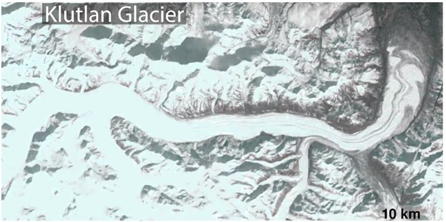
A satellite image from 1983
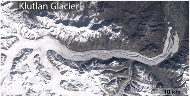
A satellite image from 2019
- Changes in Sea Levels Global warming causes sea levels to rise due to melting glaciers and expanding warm water. Satellite altimeters measure changes in sea levels with millimeter precision, providing crucial data to determine the global and regional impacts of this rise. This information is vital for the protection of coastal cities and ecosystems.
- Monitoring Vegetation and Forests Global warming leads to changes in vegetation and forest ecosystems. Satellite images are used to track deforestation, forest fires, and changes in vegetation, analyzing ecosystem health and the carbon cycle. This data forms the basis for the conservation and sustainable management of forests.
- Changes in Atmospheric Temperature and Humidity Satellite sensors measure changes in temperature and humidity at various layers of the atmosphere. This data is used to understand the effects of global warming on the atmosphere and to improve climate models. Atmospheric temperature and humidity measurements are critical for weather forecasting and climate change projections.
- Ocean Temperatures and Currents Oceans are the systems most directly affected by global warming. Satellite images and sensors monitor ocean surface temperatures and currents, analyzing their impact on marine ecosystems. This data is used to understand the health of coral reefs, fish stocks, and changes in sea levels.
Which Satellite Images Are Used?
The satellite images used to observe the effects of global warming include data obtained from various satellite systems. These systems enable the monitoring of various environmental changes by imaging at different wavelengths. Here are some important satellite systems and their features:
- Landsat Series:
- Landsat 8 and 9: These satellites provide multispectral and thermal imaging to monitor temperature changes on the land surface, vegetation, water resources, and other environmental factors. They provide high-resolution images and offer a wide range of spectral bands.
- MODIS (Moderate Resolution Imaging Spectroradiometer):
- Terra and Aqua Satellites: MODIS sensors monitor terrestrial, oceanic, and atmospheric parameters. These parameters include sea surface temperature, vegetation index, cloud cover, and aerosols.
- Sentinel Series:
- Sentinel-1: Uses radar imaging to monitor soil moisture, glacier movement, and sea ice changes, tracking the effects of global warming.
- Sentinel-2: Provides multispectral imaging to monitor vegetation, water quality, and changes on the land surface.
- Sentinel-3: Monitors sea surface temperature, land surface, and atmospheric parameters.
- AVHRR (Advanced Very High Resolution Radiometer):
- Found on NOAA satellites, this sensor is used for long-term monitoring of sea surface temperature, vegetation, and atmospheric parameters.
- ICESat-2:
- This satellite uses a laser altimeter to measure the thickness of ice sheets and changes in land surface elevation. This data is used to monitor sea-level rise and ice loss.
Conclusion Satellite images are an indispensable tool for observing and analyzing the effects of global warming. Their ability to monitor large areas with high resolution and over long periods helps us understand and combat various impacts of global warming. Accurate and precise monitoring of changes in atmospheric, oceanic, and terrestrial systems allows us to develop strategies for a more sustainable future.
At Uydushop, we offer the latest technology satellite images for monitoring and analyzing the effects of global warming. Contact us to closely monitor environmental changes and take more effective steps in combating climate change.
Hilal Yılmaz – Surveying Engineer, MSc






