In recent years, especially during the summer months, forest fires in our country have caused irreversible damage to natural ecosystems. Forests play a critical role in preserving biodiversity and combating global climate change. However, rising temperatures due to global warming, drought, and human-induced factors have increased the frequency and intensity of forest fires. This situation has made the protection and monitoring of forests more important than ever. Satellite imagery emerges as an effective tool in the protection of forest areas and in the processes of combating fires. In this article, we will discuss the role of satellite imagery in monitoring and protecting forest areas.
Monitoring Forest Areas with Satellite Imagery
Monitoring forest areas is of great importance for preventing fires, preserving biodiversity, and ensuring sustainable forest management. Satellite imagery provides high-resolution data that covers large areas and is constantly updated, making it an ideal method for monitoring the condition of forests. These data are used for early detection of forest fires, post-fire damage assessment, and monitoring the overall health of forest areas.
Benefits of Forest Monitoring with Satellite Imagery
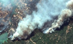
- Early Detection and Response to Fires: Satellite imagery plays a vital role in the early detection of forest fires. Data obtained from thermal bands can quickly detect temperature increases as fires start, allowing response teams to act swiftly. Additionally, satellite imagery can identify areas at risk of fire by monitoring indicators such as high temperatures or moisture stress, helping to reduce the potential damage a fire could cause.
- Post-Fire Damage Assessment: After forest fires, satellite imagery is used to determine the extent of the damage in the affected area. These images provide detailed views of burnt areas and affected vegetation. Damage assessment is crucial for planning rehabilitation and reforestation efforts.
- Preservation of Biodiversity: Satellite imagery can also be used to monitor the biodiversity of forest areas. By tracking changes in vegetation cover, habitat loss, and ecosystem health, it is possible to detect threats to biodiversity early. This allows for the development of conservation strategies and ensures the sustainability of ecosystems.
- Sustainable Forest Management: The sustainable management of forests provides long-term environmental and economic benefits. Satellite imagery supports the implementation of sustainable forest management policies by monitoring changes in forest areas over time. This ensures the efficient use of forest resources and the protection of future forests.
Techniques Used in Forest Monitoring with Satellite Imagery
- NDVI (Normalized Difference Vegetation Index): NDVI is a widely used index for monitoring vegetation density and health in forest areas. High NDVI values indicate dense and healthy vegetation, while low NDVI values may signal degradation or the presence of fires. This index is used in post-fire damage assessment and forest health monitoring.
- Satellite Systems like Sentinel: Satellite systems such as Sentinel are commonly used platforms for monitoring forest areas. These satellites scan large areas with high resolution, providing continuous information about the condition of forest areas. This data is used to monitor events such as forest fires, tree cutting, and forest diseases.
- Thermal Imaging: Thermal imaging is a technique used for the early detection of forest fires. Thermal bands monitor temperature changes in forest areas, helping to identify fire risks. Thermal imaging is a critical tool for detecting temperature increases before and during fires.
- Time Series Analysis: Time series analysis is a technique used to monitor long-term changes in forest areas. This analysis tracks the health and growth of forests over time, helping to identify potential threats early. Time series data play a significant role in developing forest management and conservation strategies.
Satellite imagery is an indispensable tool for the protection and monitoring of forest areas. The increase in forest fires in Turkey in recent years has made the use of satellite imagery even more important. Especially in the early detection of fires and damage assessment, the data provided by satellites should be encouraged. Satellite imagery also plays a critical role in planning rehabilitation and reforestation efforts after forest fires.
At Uydushop, we contribute to the sustainability of natural resources by providing the latest satellite imagery technology for the protection of forest areas. You can contact us to monitor and protect your forest areas.
Hilal Yılmaz – Surveying Engineer, MSc