The agricultural sector is vital for feeding the world’s population and economic development. However, increasing population, climate changes, and environmental factors threaten the sustainability of agricultural production. In this context, monitoring and managing crop health plays a critical role in enhancing agricultural productivity and ensuring food security. With advancing technology, satellite images are emerging as an effective tool for monitoring and managing crop health. In this article, we will explore in detail the importance of satellite images in monitoring and managing crop health.
Monitoring Crop Health with Satellite Images
Satellite images provide detailed information about the condition of agricultural areas by offering wide coverage, high resolution, and continuously updated data. This information is crucial for monitoring and managing crop health. Satellite images collect data in various wavelengths (especially near-infrared) to provide insights into the health status of vegetation. This enables early-stage monitoring of plant health and intervention when necessary.
Benefits of Monitoring Crop Health with Satellite Images
- Early Warning System Satellite images allow for the early detection of changes in plant health. This enables the early identification of plant diseases, water stress, or nutrient deficiencies. The early warning system helps farmers take quick and effective actions to prevent crop losses.
- Regional Analysis Satellite images offer the ability to conduct regional analyses by covering large agricultural areas. This allows farmers to compare plant health in different regions of their farmland and identify problematic areas. Regional analyses contribute to more efficient use of resources and increased crop productivity.
- Time Series Monitoring Satellite images enable the monitoring of crop health over time. Periodically acquired images allow for continuous tracking of plant growth and health status. This supports the development of long-term agricultural strategies and optimization of crop productivity.
- Comprehensive Data Sets Satellite images provide comprehensive data sets about plant health. These data include various parameters such as vegetation density, leaf area index (LAI), plant pigments, and water content. Comprehensive data sets are used to better understand plant health and make informed decisions.
Techniques Used in Monitoring Crop Health with Satellite Images
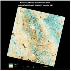
- NDVI (Normalized Difference Vegetation Index) NDVI is a widely used index for monitoring plant health. Plants reflect near-infrared light while absorbing red light. NDVI measures this reflection and absorption to provide information about plant health. High NDVI values indicate healthy and dense vegetation, while low NDVI values indicate stressed or dead plants.
- EVI (Enhanced Vegetation Index) EVI is used to monitor plant health similarly to NDVI, but it better corrects for factors such as atmospheric effects and soil background. EVI provides more accurate results in areas with dense vegetation. This is particularly useful for monitoring plant health in areas with dense vegetation.
- NDWI (Normalized Difference Water Index) NDWI is used to monitor plant water content. The water content of plants is a critical factor for their healthy growth. NDWI helps determine water stress and irrigation needs of plants. This plays an important role, especially in regions with limited water resources.
- MSAVI (Modified Soil Adjusted Vegetation Index) MSAVI is an index developed to correct for the effects of soil on vegetation. This index provides more accurate results in areas with low vegetation density. MSAVI is useful when vegetation is not masked by the soil background.
Satellite images are a critical tool for monitoring and managing crop health. Various indices such as NDVI, EVI, NDWI, and MSAVI are used to monitor plant health, water content, and soil effects. These indices provide important information to increase agricultural productivity, optimize resource use, and reduce environmental impacts. At Uydushop, we are pleased to offer the latest technology in satellite images to help you increase your agricultural productivity and develop sustainable farming practices. You can contact us to monitor and manage your crop health.
Hilal Yılmaz – Surveying Engineer, MSc