Monitoring Coastal and Marine Ecosystems: The Importance of Satellite Imagery”
In this blog post, we will discuss the role of satellite imagery in monitoring coastal and marine ecosystems. But first, let’s start by defining what an ecosystem is. An ecosystem is a natural habitat with a certain balance and continuity, where living organisms in a specific area interact with their surrounding non-living environment biological and physical components. In an ecosystem, plants, animals, and microorganisms are in constant interaction with non-living elements like soil, water, and air. Two of these habitats coastal areas and marine ecosystems play a critical role globally in preserving biodiversity, regulating the carbon cycle, and ensuring the sustainability of human activities. However, these areas face numerous threats, such as climate change, pollution, overfishing, and the expansion of coastal settlements. The protection and monitoring of coastal and marine ecosystems are vital for the sustainable management of these areas. Satellite imagery emerges as a powerful tool in this process, offering the ability to monitor large areas with high accuracy.
The Importance of Monitoring Coastal and Marine Ecosystems
Coastal and marine ecosystems form the basis of many economic activities, such as seafood production, water resources, tourism, and coastal protection. However, these valuable ecosystems are under serious threat due to human activities and natural disasters. Coastal erosion, rising sea levels, marine pollution, and the degradation of coral reefs are among the primary issues threatening coastal and marine ecosystems. To address these threats, it is necessary to regularly monitor these areas and convert the data obtained into sustainable management strategies.
Monitoring Coastal and Marine Ecosystems with Satellite Imagery
Satellite imagery is an ideal method for monitoring coastal areas and marine ecosystems. This method allows for the monitoring of changes in ecosystems over time by providing extensive coverage, frequent updates, and long-term data. Satellite imagery is used to monitor many important factors such as coastal erosion, sea surface temperatures, marine pollution, coral reefs, and water quality.
Monitoring Coastal Erosion: Coastal erosion is rapidly increasing due to rising sea levels, storms, and human activities. Satellite imagery provides critical data for monitoring changes along the coastline and determining the impacts of erosion.
Monitoring Sea Surface Temperatures: Sea surface temperatures have a direct impact on the health of marine ecosystems. Temperature changes can affect marine life, coral reefs, and ocean currents. Satellite imagery can be used to monitor sea surface temperatures and detect abnormal heat increases. This data is crucial for monitoring the impacts of climate change and determining measures to protect marine ecosystems.
Algae Detection: One of the major threats to marine ecosystems is algal blooms. Algal blooms can degrade water quality, threaten marine life, and in some cases, be toxic.
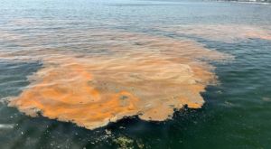
Satellite imagery can be used for the detection and monitoring of algae over large areas. For example, analyses like the Normalized Difference Chlorophyll Index (NDCI) can be used to measure algal density. This data helps in developing early intervention strategies to minimize both environmental and economic impacts.
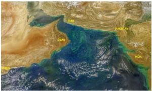
Detection of Marine Pollution: Marine pollution, particularly oil spills, plastic waste, and chemical contamination, has devastating effects on marine life. Satellite imagery is used to detect pollution on the ocean surface.
The protection of coastal areas and marine ecosystems is a critical necessity for global environmental sustainability. Satellite imagery is an indispensable tool for monitoring these valuable ecosystems. The monitoring of factors such as coastal erosion, sea surface temperatures, coral reefs, and marine pollution can be effectively carried out using satellite data. As UyduShop, we are pleased to contribute to sustainable management efforts in this area by providing the latest satellite imagery technology for the protection of marine ecosystems. You can contact us to monitor and protect your coastal and marine ecosystems.
Hilal Yılmaz – Surveying Engineer, MSc