

Hello,
This week we will look at the uses and process flow of Hyperspectral Imagery. In last week’s blog post we compared HS and MS images and gave detailed information.
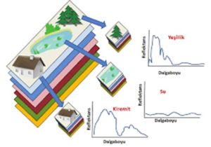
Hyperspectral images are images with multiple spectral bands produced by imaging systems that can simultaneously obtain information from specific bands across a broad electromagnetic spectrum. These features enable their use in various application areas. Here are some of the application areas of hyperspectral images:
Agriculture and Plant Health Monitoring:
Hyperspectral images are used in agriculture to monitor plant health, detect diseases, and determine factors like water stress.
Forest Management:
Hyperspectral images are used to monitor the condition of forests, distinguish tree species, and identify issues like deforestation.
Environmental Monitoring:
Hyperspectral images are used to assess water quality, identify environmental pollution, and monitor natural resources.
Mineral Exploration and Mining:
Hyperspectral images are used to detect mineral reserves and analyze mineral composition.
Defense and Security:
Hyperspectral images can be used to detect enemy targets, monitor chemical leaks, and for military reconnaissance purposes.
Medical Imaging:
Hyperspectral images can be used to examine the spectral properties of tissues and organs for use in surgical procedures.
Soil Analysis:
Hyperspectral images can be used to determine soil properties, distinguish soil types, and improve agricultural productivity.
Water Resources Monitoring:
Hyperspectral images are used to determine water quality, detect water pollution, and manage water resources.
Remote Sensing and Mapping:
Hyperspectral images can be used in remote sensing and mapping applications to monitor surface features and changes.
Hyperspectral images can be effectively utilized in various industries by providing detailed and customized information in numerous application areas.
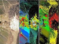
Processing data using hyperspectral images involves several steps. Below are the general processing steps for using hyperspectral images:
Data Acquisition:
Hyperspectral images are collected using sensors such as satellites, aircraft, or unmanned aerial vehicles (UAVs).
Temperature correction processes are applied to correct temperature effects during data collection.
The collected data is divided into spectral bands representing the surface spectrum over a specific region.
Band Selection and Preprocessing:
Spectral bands relevant to the water changes being monitored are selected.
Preprocessing steps such as radiometric calibration and spectral correction are applied.
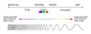
Calculation of Spectral Indices:
Spectral indices that can be associated with specific water changes are calculated. For example, indices like NDVI (Normalized Difference Vegetation Index) can help monitor vegetation and water content.
Generation of Spectral Signatures:
Spectral signatures are determined using hyperspectral data.
Change Analysis:
Differences between hyperspectral images over time are analyzed. This change analysis is used to determine changes in the surface.
Classification and Mapping:
Classification and mapping techniques can be applied. This step allows visualizing changes in a specific area on a map.
Evaluation of Results:
The obtained results are evaluated and interpreted. This is important for understanding the impacts on resource management and change.
These steps provide a general framework, but the processing steps may vary depending on specific applications and projects. Depending on the application domain, more complex algorithms and modeling techniques can also be used.
To sum up multiband satellites have revolutionized remote sensing, offering a vast array of applications from environmental monitoring to urban planning. Among these advanced capabilities, satellite hyperspectral imaging stands out for its unparalleled detail and specificity. By capturing data across hundreds of narrow spectral bands, these satellites provide invaluable insights into Earth’s surface composition and dynamics. Furthermore, the integration of thermal hyperspectral data adds another dimension, enabling the detection of subtle temperature variations indicative of various phenomena. The synergy between multiband and thermal hyperspectral imagery opens new avenues for scientific research, disaster response, and resource management, promising a more comprehensive understanding of our planet’s intricate systems.
Don’t forget to visit UyduShop for the fastest and most cost-effective images.






