

Satellite imagery is a powerful tool for mineral detection and exploration of mineral resources. By remotely monitoring the earth’s surface, this technology is used to detect and study mineral sites.
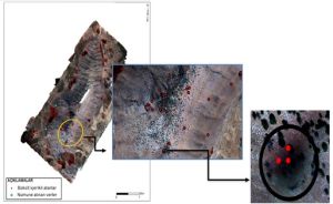
Satellite imagery has become an indispensable tool in the process of mineral detection. This technology offers great potential for the discovery of underground resources and monitoring of mining areas by swiftly and effectively surveying vast regions of the Earth’s surface. One of the primary benefits of satellite imagery in mineral detection is its ability to observe large areas simultaneously, aiding in the quicker and more economical identification of mining sites.
Optical sensors effectively collect reflection values of surface data, enabling the detection of alteration zones, anomalies, and mineral areas on the surface. One of the objectives in fields related to remote sensing methods is to narrow down the search area by identifying locations with high mineral density.
In the use of satellite imagery for mineral detection, spectral analysis plays a significant role. Satellite images capture bands at different wavelengths, and these spectral data are utilized to assess the chemical compositions and mineral enrichments of minerals. Particularly in the detection of iron, copper, gold, and other valuable metals, spectral indices (such as Iron Index and Clay Index) are crucial for identifying mining areas.
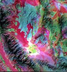
Satellite imagery is also used to monitor the environmental impacts of mines, track the expansion of mining areas, identify land use changes, and monitor compliance with environmental regulations. This helps promote sustainable mining practices.
In conclusion, satellite imagery holds great value in the process of mineral detection. Technological advancements and the increased availability of high-resolution satellite imagery offer the mining industry greater efficiency, sustainable management of natural resources, and environmental monitoring opportunities. When satellite imagery is successfully used in the discovery and management of mining areas, it can enhance the sustainability and efficiency of this sector.
You can conduct archive searches for MS data and request missions for new captures through uydushop.com.tr. All of these processes continue online. You can purchase images for even just 1 km2 without a limit on the area in archive images, and you only pay for the km2 you acquire.
To sum up space mine detection has become increasingly crucial as nations venture further into outer space. The development of advanced technologies, such as mine detection satellites, has become paramount for ensuring the safety of space missions and preventing potential conflicts. These satellites utilize cutting-edge sensors and imaging systems to detect and track objects, including space mines, in orbit. By employing a combination of radar, infrared, and other detection mechanisms, these satellites can effectively identify potential threats and provide crucial data for space agencies and military organizations. The deployment of mine detection satellites marks a significant advancement in space security, enhancing our ability to navigate the cosmos safely and responsibly.
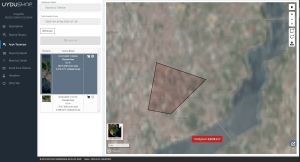
Don’t forget to visit UyduShop, which offers the fastest and most cost-effective images.






