

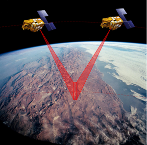
Stereo satellite imagery is the use of two or more satellite images that capture the same area from different perspectives. This type of imagery makes it possible to observe different perspectives of the same objects, allowing to obtain three-dimensional information.
Application Areas
3D Map Creation: Stereo satellite images are used to create a three-dimensional model of the surface. This enables the creation of detailed 3D maps containing height information for terrain, buildings, roads, and other objects, which is crucial for geographic information system (GIS) projects.
Topographic Analysis: Stereo images are used to examine the topographic features of an area. They are employed in topographic analysis, including height profiles, slope analysis, and determination of terrain characteristics.
Land Planning and Construction: For construction projects and land planning, stereo satellite images are used to understand existing land conditions and optimize designs.
Geodesy: Stereo images are utilized in geodesy studies, particularly in measuring and mapping changing surface elevations.
Environmental Monitoring: Stereo satellite images are used to monitor environmental changes and assess damages following natural disasters.
Transportation and Logistics: Stereo satellite images can be used for transportation infrastructure planning and management, including roads, railways, and airports.

Advantages
Three-Dimensional Information: Stereo satellite images contain height information for objects, allowing for a richer and more complete representation of geographic data.
High Precision: Stereo images provide the ability to determine the position of objects on the surface more accurately, which is important in construction, land planning, and geodesy.
Detailed Analysis: Stereo satellite images enable a more detailed analysis of terrain features and topographic details.
Geographic Information Systems (GIS): Stereo images serve as an important data source for geographic information system (GIS) projects, contributing to the creation of more comprehensive and accurate maps.
Monitoring Changes: Stereo satellite images are used to monitor environmental changes and changes in land use, which is important for natural resource management and environmental monitoring.
Stereo satellite images have become an indispensable tool for various applications in many industries and scientific fields, helping to better understand geographic data and make better decisions due to their high precision and three-dimensional information capabilities.

To sum up, stereo satellites revolutionize our perception of Earth’s topography and infrastructure. These advanced satellites capture imagery with unparalleled precision, enabling us to visualize landscapes in three dimensions with stunning detail. By integrating data from stereo and 3D satellites, scientists and planners gain deeper insights into terrain morphology, urban development, and environmental changes. This technology isn’t just about visual appeal; it’s a powerful tool for disaster management, urban planning, and environmental monitoring. With stereo satellite imagery, we’re not just viewing the world; we’re understanding it in a whole new dimension.
You can visit UyduShop for image supply.






