

Remote sensing is the process of examining and collecting data about the Earth’s surface through remote sensors. This process obtains information from the Earth’s surface using electromagnetic radiation (e.g., visible light, infrared, microwave). Resolution refers to the level of detail present in remote sensing data.
There are four different types of resolution in remote sensing: spectral, radiometric, spatial, and temporal resolution. When working with satellite images, it is essential to understand all types of resolution and know the resolution specifications of each satellite when obtaining images from uydushop.com.tr to ensure we get the most suitable images for our project. In this article, we will answer the question: what is spectral resolution?

Spectral resolution defines a sensor’s ability to distinguish between different wavelength ranges. No single sensor is sensitive to all wavelengths of the electromagnetic spectrum. When considering the spectral resolution of sensors, the number of regions of the electromagnetic spectrum they can detect, i.e., the number of bands, is a primary factor. However, the number of bands alone does not equate to spectral resolution. The position of these bands within the electromagnetic spectrum must also be taken into account.
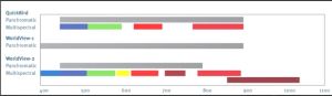
Remote sensing sensors detect electromagnetic radiation in specific spectral bands and present this information in image or data format. Spectral resolution indicates how detailed the data collected by these sensors can be across different spectral bands. Higher spectral resolution allows for more detailed detection of a greater number of spectral bands (colors or wavelength ranges).
For example, in a remote sensing study used for vegetation health analysis, different plant species or diseases may exhibit different behaviors in specific infrared spectral bands. A sensor with higher spectral resolution can detect these differences more precisely.
Spectral resolution refers to how many different spectral bands a sensor collects data in and how narrow or broad these bands are. Higher spectral resolution means the ability to collect data over a wider spectral range, enabling more detailed and accurate results.
Spectral resolution is crucial for the quality and usability of remote sensing data. Here are some points where spectral resolution is important:
Object Identification and Classification: Data collected in different spectral bands allows for better identification and classification of object types and surface features. For example, plant species, soil types, water bodies, and other surface features behave differently in various spectral bands. High spectral resolution helps detect these differences more precisely.
Vegetation Health and Agricultural Analysis: Spectral data used for monitoring vegetation health enables the assessment of factors such as photosynthetic activity, water stress, disease, or pest presence. High spectral resolution makes vegetation health analysis more accurate and reliable.
Monitoring Environmental Changes: Spectral data is used to monitor environmental changes such as deforestation, soil erosion, and water quality changes. Analyses conducted in different spectral bands help detect natural and human-induced impacts.
Mineral and Mining Exploration: Different minerals and their components have distinct spectral properties. Remote sensing data is used for detecting and analyzing underground resources. High spectral resolution is important for mining exploration and geological research.
Atmospheric and Weather Monitoring: Detecting specific gases or particles in the atmosphere, monitoring air quality, and analyzing atmospheric components require spectral resolution.
Archaeological Research: Remote sensing data with spectral resolution is used to determine different surface features and trace ancient structures in historical and archaeological sites.
As seen from the examples above, spectral resolution is essential in remote sensing for obtaining accurate results and effectively monitoring changes in various application areas.
Don’t forget to visit UyduShop for the fastest and most cost-effective images.






