

Satellite data has become an indispensable tool for local governments to protect their assets, preserve and manage land resources, and respond quickly and effectively to unforeseen emergencies. With the help of advanced satellite technologies, local governments can monitor and analyze various environmental factors such as land use, water resources, weather conditions, and natural disasters. This allows them to make informed decisions, take proactive measures, and mitigate potential risks. By leveraging satellite data, local governments can ensure the safety and well-being of their citizens while also protecting the lands they manage.
Protection of Public Assets
Local governments are responsible for various critical assets, including public services, and use satellite imagery as a proactive tool to protect these assets. For example, public services can be both private and public. If they are public, local governments have the responsibility to monitor and maintain these assets within their jurisdiction. Many government agencies use satellite monitoring for consistent asset surveillance. By continuously monitoring these assets from space, authorities can detect subtle changes or anomalies that may indicate potential issues such as structural damage or wear and tear. The ability to monitor assets on a weekly or monthly basis supports detailed record-keeping and timely intervention.
One important consideration for government agencies is ensuring the safety of field workers, preventing potential accidents, and minimizing disruptions to essential services. Satellite data provides an effective alternative to manual inspections, saving time and resources.
Land Preservation
Departments managing parks and natural resources can utilize satellite data for comprehensive land monitoring. Regular analysis of satellite imagery allows local governments to detect changes in land cover, vegetation, and ecosystem health. This enables them to make informed land use, conservation, and development decisions. Additionally, the data helps in the early detection of environmental threats such as deforestation or habitat degradation, allowing authorities to take timely action to protect biodiversity and natural landscapes.
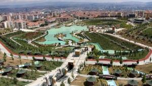
For example, let’s assume that the local parks department plans to build a new park to preserve greenery and provide recreational areas for the public. Planning and coordination are essential to ensure that the proposed recreation trails do not interfere with the natural habitat they aim to protect. Satellite imagery can be used to map the area, identify the wildlife and vegetation in the region, and ensure that the planned trails do not disrupt the ecosystem. Documenting this information before constructing the park helps maintain ecological balance and ensures that the park is safely planned without harming the ecosystem.
Emergency Response
Periodic monitoring of counties and districts aids in creating comprehensive pre- and post-event analyses, identifying high-risk areas, and developing proactive emergency plans. This not only supports citizens in promptly reporting insurance claims but also ensures that emergency response resources are directed to the areas in greatest need.
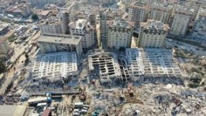
For example, in the event of a major earthquake, satellite imagery can be used to identify damaged areas. Satellite imagery also helps the government monitor the earthquake and determine when it is safe to send workers for repairs. In this case, satellite imagery prioritizes the safety of city workers and the efficiency of rapid response efforts.
Satellite data emerges as a crucial tool in the decision-making processes of local governments, spanning various areas such as the protection of public assets, land management, and emergency response. The effective use of this technology is of great importance for the safety and well-being of both citizens and the managed lands.
Uydushop: Harness the Power of Satellite Data
If you want to satellite data, visit our Uydushop platform. With our advanced satellite imaging services, you can protect your assets, manage your land resources, and respond effectively to emergencies. Uydushop provides you with the data you need, helping you optimize your management processes.
Hilal Yılmaz – Surveying Engineer, MSc






