

Water is one of the most critical natural resources on Earth. The sustainable management of water reservoirs is vital for agriculture, industry, energy production, and daily life. The protection and management of water resources are becoming increasingly important under the pressure of factors such as climate change, population growth, and pollution. In this blog post, we will examine in detail the role of satellite imagery in monitoring and managing water reservoirs.
Monitoring Water Reservoirs with Satellite Imagery
Satellite imagery allows for the monitoring of large areas at high resolution and regular intervals. These features provide valuable information about the status, quality, and quantity of water reservoirs. Here are some key applications of satellite imagery in monitoring water reservoirs:
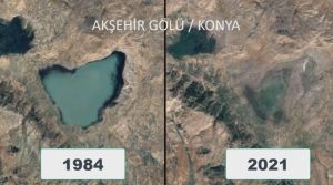
- Monitoring Dam and Lake Levels Satellite imagery is an effective tool for monitoring the levels of water reservoirs such as dams, natural lakes, and ponds. High-resolution satellite images can accurately detect changes in water levels. This information helps water management authorities optimize water usage and effectively manage water resources during drought periods.
- Monitoring Groundwater Reservoirs Groundwater is one of the world’s most important water resources and provides drinking water for millions of people. Satellite imagery and other remote sensing techniques play a critical role in monitoring groundwater reservoirs. Gravimetric satellite data can be used to determine changes in groundwater levels. NASA’s GRACE (Gravity Recovery and Climate Experiment) satellite data, which detects small changes in the Earth’s gravity field caused by the distribution of underground water, has been successfully used. This makes water management policies more sustainable.
- Monitoring River and Stream Flows Satellite imagery is also used to monitor the flows of rivers and streams. Water flow data is essential for identifying flood risks, monitoring water quality, and preserving ecosystem health. Especially during flood periods, satellite imagery provides rapid and comprehensive data, enhancing the effectiveness of emergency response plans.
- Protecting and Managing Wetlands Wetlands are areas rich in biodiversity and of critical ecological importance. Satellite imagery is used to monitor the condition of wetlands and detect changes. This ensures the protection and sustainable management of wetlands. Satellite data is used to monitor area changes, water quality, and vegetation in wetland regions.
Satellite imagery is a revolutionary tool for monitoring and managing water reservoirs. The high-resolution and regular monitoring of large areas make the sustainable management of water resources possible. The precise and accurate data provided on water levels, flow rates, quality, and the condition of wetlands enhances the effectiveness of water management policies.
At Uydushop, we offer the latest technology satellite images for monitoring and managing water reservoirs. You can contact us to support the sustainable management of your water resources and closely monitor the condition of your water reservoirs.
Hilal Yılmaz – Surveying Engineer, MSc






