

Hello and welcome to my first blog post. Today, we will be exploring SAR technology. I hope this blog post will help to clear up any confusion about SAR systems.
Synthetic Aperture Radar (SAR) is a radar technology that operates in the microwave bands of the Electromagnetic spectrum to obtain high-resolution images of objects. The working principle is based on interacting with objects on the earth’s surface and receiving and processing the signals reflected from these objects by SAR antennas.
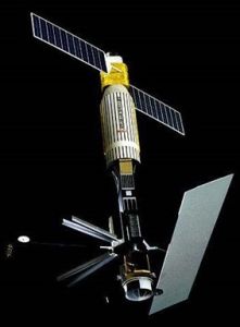
The first SAR satellite: SeaSAT (Wikipedia)
The first SAR satellite was SeaSAT, which was launched in 1978 to map the topography of the oceans on Earth. As the ease and utility of SAR systems for wide-area applications were recognized, many SAR systems have been produced to this day and continue to be produced.

Various SAR systems produced up to the present day (Aswathi et al., 2022)
SAR data, providing high-resolution surface details of objects, offer advantages that traditional optical images cannot provide.
These advantages include:
- Independence from weather conditions: SAR systems, operating using microwave energy, are not affected by weather conditions. Atmospheric conditions such as clouds, fog, or rain do not hinder SAR systems from collecting data. This feature enables SAR to collect data at all times, even in conditions where optical images cannot be obtained.
- Availability at all times of the day: While optical images rely on sunlight, SAR systems can collect data in darkness or at any time of the day. This can be highly valuable in applications requiring night vision or in regions with long or entirely dark days, such as polar areas.
- Penetration through surface cover: Optical images cannot see details under cloud layers or vegetation cover. However, SAR can penetrate beneath the surface of objects or cover. This feature is very useful in applications such as examining terrain features under forests or the topography beneath water bodies.
- High resolution and sensitivity: SAR can produce high-resolution and detailed images. Additionally, it can track the movement of objects and detect changes. This feature is important in applications such as monitoring land changes, post-earthquake damage, or growth trends in agricultural areas.
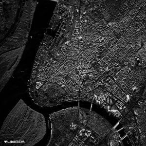
SAR Image of Umbra
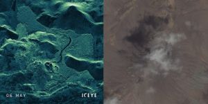
©ICEYE ve Maxar Technologies – Comparison of SAR and optical images of the Fagradalsfjall Volcano
The volcano is a great example of a radar or SAR image taken this year. You can clearly see the crack line through the volcano’s smoke and ash.
The applications of SAR include agriculture monitoring, forestry, water resource management, disaster monitoring, urban planning, and military intelligence, among many others. These data can provide valuable information such as monitoring surface changes, determining terrain topography, tracking water movement, and detecting structures.
What is InSAR?
Interferometric Synthetic Aperture Radar (known as InSAR) is a technique that utilizes SAR data. Simply put, it is a mapping technique for ground movement using SAR. Interferometry uses SAR data to detect surface movements and displacements of up to ±4 mm with an accuracy of up to 30 mm. The technique requires two or more precise SAR images taken at different times. If there has been any surface movement, a phenomenon called phase shifting occurs, which is measured and recorded through an interferogram.
Let’s return to the volcano and look at the image below to see what we mean with interferogram.
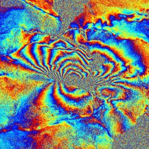
This image is definitely colorful, but InSAR data is displayed in this way. Each color represents a depth value to reveal surface movement caused by phase shifts.
InSAR is an extremely precise technique for detecting terrain deformation and is excellent for many applications. Imagine monitoring urban developments. So… Is the Leaning Tower of Pisa leaning too much? Construction, city planning, transportation, mining, and the oil and gas industries can all benefit from the brilliance of InSAR. Natural events such as landslides detection or determination of tectonic deformations are fundamental use cases for InSAR. The technology is always advancing with new imaging equipment.
In conclusion, SAR holds a significant place in remote sensing technology. Providing high-resolution, weather-independent, and penetrative imaging, it is a valuable tool in many applications.
To sum up synthetic aperture radar (SAR) technology has revolutionized satellite radar imaging. By employing advanced signal processing techniques, SAR systems can generate high-resolution images of the Earth’s surface regardless of weather conditions or time of day. These systems emit microwave signals towards the ground and record the reflections, allowing for the creation of detailed radar images. The versatility of synthetic aperture radar makes it invaluable for various applications, including agriculture, urban planning, and environmental monitoring. Satellite radar equipped with SAR capabilities plays a crucial role in gathering data for disaster management, oceanography, and surveillance. Its ability to penetrate through clouds and foliage provides researchers and decision-makers with unparalleled insights into our changing planet. As technology continues to evolve, the capabilities of synthetic aperture radar and satellite radar are expected to further expand, enhancing our understanding of Earth’s dynamics and facilitating informed decision-making on a global scale.
I hope this article has shed some light on SAR technology for you. If you’re curious to learn more or want to explore satellite imagery for yourself, don’t forget to visit UyduShop!
Hilal Yılmaz – Surveying Engineer, MSc






