

Spot 6 is a high-resolution optical satellite system developed by Airbus Defense and Space. It is used to observe the Earth’s surface with high quality imagery and provide data for a range of applications. Spot 6 has a ground resolution of 1.5 meters.
| Orbit Altitude | 694 km |
|---|---|
| Orbit Type | Sun-synchronous |
| Orbit Inclination | 98.2° |
| Orbit Duration | 98.79 min |
| Repeat Cycle | 26 days |
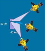
Spot 6 was launched in 2012 and has been actively used to monitor and image the Earth’s surface ever since. The satellite has high-resolution optical cameras and is capable of capturing color images of the Earth’s surface at various wavelengths. This allows Spot 6 to be used in many different application areas.

Spot 6’s main areas of use include:
Environmental Monitoring: Spot 6 is used to monitor the effects of natural disasters, detect forest fires, monitor water resources, and track environmental changes.
Agriculture: In agriculture, Spot 6 data is used to monitor plant health, increase productivity, and manage agricultural areas. Monitoring plant diseases, drought, and crop forecasting play significant roles in these areas.
Forestry: Spot 6 images are used to monitor forest resources, prevent deforestation and forest fires. Emergencies such as forest fires are also monitored.
Mapping: Spot 6 provides fundamental data for map creation and geographic information system (GIS) applications. It is used in infrastructure planning, land use, and urban development.
Transportation and Infrastructure: Satellite data is used in areas such as transportation projects, port management, and infrastructure monitoring. It contributes to the development of roads, railways, and airports.
Emergency Response: During natural disasters, emergencies, or crises, Spot 6 is used to coordinate rescue operations and assess damage.
Spot 6 supports a wide range of applications worldwide, from scientific research to commercial activities, in these and similar fields. By providing high-resolution images, it helps society better understand changes on Earth and provides important information to decision-makers.
To sum up you can download SPOT-6 satellite imagery from various sources online. SPOT-6, developed by Airbus Defence and Space, provides high-resolution optical images of Earth’s surface. These images are invaluable for various applications, including urban planning, agriculture, and environmental monitoring. Accessing SPOT-6 imagery enables researchers, policymakers, and businesses to make informed decisions based on up-to-date geospatial information. Whether you need detailed maps for infrastructure development or insights into land cover changes, leveraging SPOT-6 data can enhance your projects and analyses.
You can sign up for UyduShop and start exploring now.






