

In our previous blog post, we discussed InSAR technology in detail. To give a brief reminder; InSAR is a special radar processing technique that uses SAR technology to monitor changes on the earth’s surface. InSAR measures surface deformations and height changes by comparing SAR images of the same area at different times. This technique is used to accurately map ground movements in the field.
The mining industry, on the other hand, has made significant progress in recent years by using satellite images for various purposes such as field monitoring, research planning, resource searching, and environmental monitoring.
The use of InSAR in the mining industry includes:
- Monitoring Underground Mining Operations: InSAR is used to determine the deformations of underground cavities in mines. Monitoring areas of fracture or collapse underground is critical for safety.
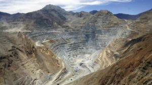
- Monitoring Rock Slope Deformations: InSAR is used to monitor rock slope deformations in open-pit mines. This can help detect rock falls in advance.
- Monitoring Underground Water Levels: InSAR can be used to monitor changes in underground water levels. This is important in determining water management and environmental impacts at mining sites.
Radar-based imaging techniques like SAR and InSAR play a critical role in monitoring operations, safety, and environmental impact assessments in the mining industry. These technologies, combined with remote sensing and data analytics, provide effective management and monitoring at mining sites.
The advantages of InSAR technology in the mining industry are as follows:
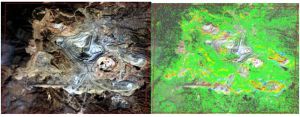
- High Precision Motion Tracking: InSAR can determine movements with precision at the millimeter/year level. This scale allows for continuous monitoring of any abnormal movement in old mining sites. This provides operators with an important tool to detect potential risks early and take preventive measures.
- Remote and Automatic Monitoring: InSAR can be used to evaluate, monitor, and receive alerts for excessive ground movements in all mining sites without the need for bots or manual equipment on the ground. This provides continuous and automatic monitoring while reducing human intervention.
- Optimization of Maintenance Activities: InSAR data can help optimize ground-based monitoring systems and maintenance activities. Detailed monitoring and analysis of movements in the field allow maintenance plans to be structured more effectively. For example, potential risks in certain areas can be identified in advance, allowing maintenance work to be done on time and when necessary.
- Efficiency and Cost Savings: Continuous monitoring with InSAR allows operations to be managed more efficiently and cost-effectively. Early detection of potential hazards allows for timely preventive actions, which can reduce operating costs and increase productivity.
- Monitoring Environmental Impacts: InSAR can also help monitor the environmental impacts of mining activities. Detailed mapping of ground movements can contribute to identifying environmental changes and potential sources of pollution.
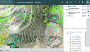
The advantages of InSAR technology enable operations in the mining industry to be managed in a safer, more sustainable, and efficient manner. With the use of this technology, the mining sector can reduce risks; ensure the safety of workers and people in the vicinity, and minimize environmental impacts, moving towards a more sustainable future.
To sum up InSAR deformation mining and deformation mapping in mines have revolutionized the way we monitor and analyze ground movements in mining areas. By employing advanced satellite technology, these methods offer a comprehensive understanding of surface deformations, aiding in risk assessment, safety management, and resource optimization within mining operations. With InSAR, precise measurements of ground displacements can be obtained over large areas, enabling early detection of potential hazards such as subsidence or slope instability. Deformation mapping further enhances this capability by providing detailed spatial information, allowing for targeted interventions and proactive planning. Together, these techniques contribute to safer and more efficient mining practices, ultimately ensuring sustainable resource extraction while mitigating environmental risks associated with deformation mapping mine.
If you’re curious to learn more or want to explore satellite images with your own eyes, don’t forget to visit UyduShop!
Hilal Yılmaz – Surveying Engineer, MSc






