

Natural disasters are sudden and destructive events that profoundly impact societies and the environment. Earthquakes, hurricanes, floods, wildfires, and volcanic eruptions can cause loss of life and property, destroy infrastructure systems, and lead to long-term social and economic consequences. Rapid and effective response to such events is critical to minimizing damage and ensuring the success of recovery efforts.
Using Satellite Images for Rapid Response and Assessment After Natural Disasters
Satellite images emerge as an indispensable tool for rapid response and assessment after natural disasters. In this article, we will examine in detail how satellite images are used after natural disasters and the benefits they provide.
Applications of Satellite Images in Natural Disaster Response
- Rapid Damage Assessment Immediately after natural disasters, satellite images help quickly evaluate the overall condition of the affected area. High-resolution images provide detailed information about collapsed structures, damaged infrastructure, and affected areas. This information allows emergency response teams to allocate resources most effectively.
- Mapping the Disaster Area Satellite images are used to produce comprehensive and up-to-date maps of the disaster area. These maps are critical for the operations of rescue and aid teams. Accurate mapping of the affected areas optimizes logistical planning and aid distribution.
- Emergency Communication and Coordination Satellite images are an important tool for ensuring communication and coordination after disasters. Satellite data provides current and accurate information about the condition of the disaster area, enhancing the coordination of decision-makers and response teams. This is especially vital when communication infrastructure is damaged.
- Search and Rescue Operations Satellite images are used to guide search and rescue operations. By providing information about collapsed buildings, road blockages, and other hazards in the affected areas, they enable rescue teams to work safely and effectively.
- Logistics and Aid Distribution Rapid and accurate distribution of aid supplies is critical after natural disasters. Satellite images are used to determine the most suitable routes and safe passage points for aid distribution. This ensures that aid supplies reach those in need as quickly as possible.
- Long-Term Reconstruction and Rehabilitation Satellite images also play an important role in the post-disaster reconstruction and rehabilitation processes. They can be used to monitor the recovery process of the affected areas and plan reconstruction projects. This helps build more resilient structures and infrastructures for future disasters.
Benefits of Satellite Images
- Speed and Accessibility Satellite images cover large areas quickly, allowing for a rapid assessment of the overall condition of the disaster area. This accelerates the response process and prevents time loss in emergencies.
- High Resolution and Detailed Images Modern satellite technologies offer high-resolution and detailed images. This is important for better understanding the extent and severity of damage. High-resolution images allow for more accurate assessments by detecting even small details.
- Real-Time Data Flow Satellite images provide a real-time data flow, making it possible to continuously monitor the disaster area. This ensures that response teams operate with the most up-to-date information and adjust their strategies accordingly.
- Interdisciplinary Use Satellite images can be used by experts from various disciplines. Geologists, meteorologists, engineers, and healthcare professionals can analyze satellite data to develop a more holistic approach.
Example Applications
- Nepal Earthquake (2015) After the major earthquake in Nepal in 2015, satellite images were used for damage assessment and rescue operations. Satellite data was utilized to determine the condition of collapsed buildings and infrastructure, thereby increasing the efficiency of rescue teams.
- Typhoon Haiyan (2013) After Typhoon Haiyan struck the Philippines in 2013, satellite images were used for mapping the disaster area and planning aid distribution. Satellite data guided aid teams by evaluating the destruction and flooding in the affected areas.
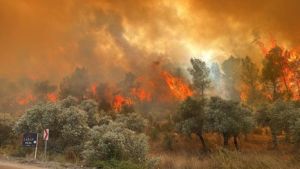
- Mediterranean Region Wildfires Wildfires in the Mediterranean region at various times have been examined with the help of satellite images. The burned area and burn severity were assessed, and the effectiveness of post-fire forest rehabilitation efforts was determined.
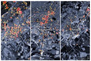
- Turkey Earthquake of February 6, 2023 For the major earthquakes that occurred in Turkey on February 6, 2023, satellite images were used to conduct a study showing the areas that sustained damage.
Satellite images are an indispensable tool for rapid response and damage assessment after natural disasters. Their ability to monitor large areas quickly and in detail provides critical information in emergencies, enhancing the effectiveness of response teams. The benefits provided in rapid damage assessment, mapping the disaster area, emergency communication and coordination, search and rescue operations, logistics, and aid distribution demonstrate the significant role of satellite images in disaster management.
At Uydushop, we offer the latest satellite imagery technology for rapid and effective response after natural disasters. For accurate and timely information in disaster situations and to develop effective response strategies, please contact us.
Hilal Yılmaz – Surveying Engineer, MSc






